Google Earth Graph
Advertisement
Plex.Earth Tools for AutoCAD
AutoCAD plug-in for advanced geographic interaction with Google Earth. Cover large areas with color imagery. Geo-locate site plans. Unique productivity tool with must-have features necessary for all engineers and architects. Plex.Earth is providing you a
Advertisement
LandMap Vivo v.10 10
Create GPS enabled geo maps directly on the background of aereal photos and road maps from the internet. Import geodata from Google-Earth, OpenStreetMap, GPS tracks and GPS logger. Map editor , manually digitizing.
Korti v.2 8
Korti is a Google Earth plugin which allows you to see the unique 3D satellite map of Korti within your Google Earth application. Korti provides you a detailed satellite imagery and geographic information about this geographic place.
ChartAid v.2 2
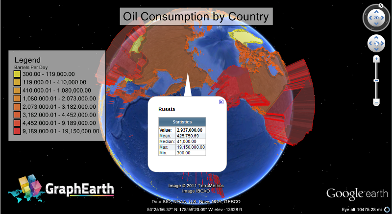
Many people have found Google Earth and Google Maps printable images helpful in supplementing their knowledge of a particular area or specific location.
Petacon v.1.0
Get a full 3D satellite map view of El Petacon on your PC. If you have already installed Google Earth, you will be able to view the El Petacón 3D map.
Nanako v.1 1
Nanako is a useful tool for Google Earth 3D map which allows you to view the exciting places of Nanako. If you have installed on your PC Google Earth tool, you can view the 3D map of Nanako places.
Veruela v.2 1
Veruela is a Google Earth utility which provides you images from Veruela geographical area.
3D Route Builder v.1.3.7.0
3D Route Builder is a strong GPS editor for fine grain control over paths directly in Google Earth. These can then be either built from scratch or based on existing KML/KMZ, GPX or Garmin Training Center TCX.
AquaSoft Earth Pilot
Google Earth flight simulation, makes map videos of flights to your destinations. Experience your journey twice. Insert start and destination, open Google Earth flight simulator and create video. Just take off - Earth Pilot takes care of the rest. Imports
Earth Satellite v.1
Download the new version of Google Earth satellite with Google Pack.Google pack includes 13 totally free software selected by google for your better internet experience.Software included in google pack - Google Earth,Norton Security Scan,